Antarctic Discovery
Description
This section is from "The American Cyclopaedia", by George Ripley And Charles A. Dana. Also available from Amazon: The New American Cyclopædia. 16 volumes complete..
Antarctic Discovery
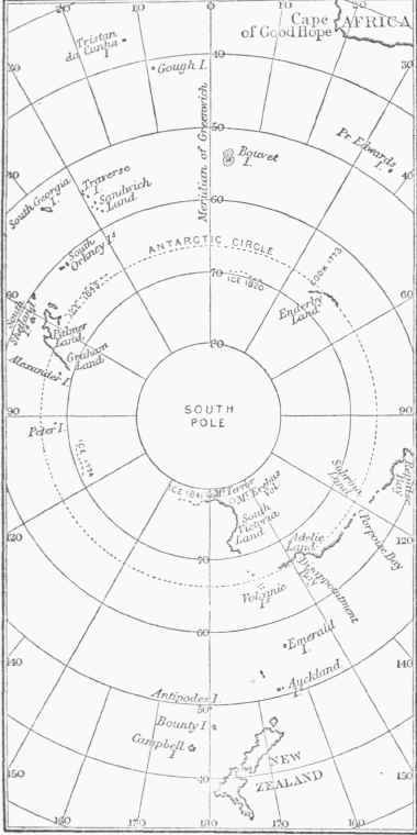
The ancient geographers, among others the Greek Ptolemy, supposed a continent to exist near the south pole, and to extend to a great distance around it. On nearly all maps published before the middle of the last century, this continent is vaguely given as " Terra Australia Incognita.11 Captain Cook, by his second voyage, first threw doubt upon this theory. He was everywhere prevented by large masses of ice from reaching any high southern latitudes, and he could discover no land. In the few cases in which he passed beyond the Antarctic circle he reached only 61° 10' S. latitude. In 1819 the South Shetland islands were seen but not visited by Capt. William Smith, the commander of a merchant vessel, driven far to the south in trying to round Cape Horn. In 1821 Trinity land, lying S. of the South Shetlands, in about lat. 62° S., was discovered by Howell, an Englishman; Palmer's land to the westward of Trinity land, forming a part of the same coast line, by Palmer, an American; and still further to the south and west the Russian Bellinghausen found Alexander's land.
Weddell, the next English explorer, made no discoveries of land, but reached lat. 74° 15' S. Enderby's land, lat. 67° 30' &., long. 50° E., and Graham's land, a still further southwestern extension of Palmer's land, were discovered in 1831 and 1832 by Biscoe, who circumnavigated the southern ice region, an expedition having been fitted out for the purpose by Messrs. Enderby, merchants of London. In 1837 and 1838 Du-mont d'Urville and Balleny made comparatively unimportant explorations; and in 1839 the Trench and American governments each sent out an expedition for a voyage of discovery in the Southern ocean. Dumont d'Urville commanded the French ships, and Lieut. Charles Wilkes the United States fleet of four vessels. On Jan. 16, 1842, Wilkes's officers discovered land from the masthead in about Ion. 160° E., lat.61°S. The expedition followed the indications of land to the westward for several days, and afterward for several weeks sailed along an immense ice field, which Wilkes thought to be a continuous barrier lying along the coast of an antarctic continent.
As he saw land only at a few widely separated points, his inference that there existed a continuous coast line is one that greatly needs confirmation; islands lay all about his course a little further to the north, and they may easily have been the only interruptions the solid ice floe found to the south. The French expedition under D'Urville also discovered a considerable extent of coast in the same quarter, and named it Adelie; but he succeeded no more than Wilkes in establishing the fact of its continuity for any great distance. It is now generally conceded that it would be rash to assume from the results of these two expeditions that the existence of a great antarctic continent is proved. - In January, 1841, Capt. James Clarke Ross, who commanded an English expedition in the Erebus and Terror, discovered a line of coast trending southward from a point near lat. 70° 41' S., Ion. 172° 30' E. Here were mountains 9,000 to 12,000 feet high, of volcanic origin; one, Mt. Erebus, inlat. 77°32'S., Ion. 167° E., was active, and near it was an extinct crater which Ross called Mt. Terror. The whole line of coast discovered by Ross was steep and rocky, and the land he saw (Victoria Land) was, like almost all that seen by the other explorers, entirely bare. - Since 1842 no important discoveries have been made in the antarctic seas.
Continue to:
My Books

